Turks and Caicos Diving from Providenciales: Park Buoys, a Wreck Restricted Area and the Humpback Months
 by Yannick Schroth
Sep 24, 2026
17 min read
by Yannick Schroth
Sep 24, 2026
17 min read
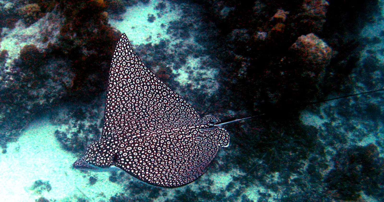
A spotted eagle ray at Coral Gardens, Princess Alexandra National Park, Providenciales, December 2006. Photo: uploaded by “the manta ray had a family”, Wikimedia Commons, public domain.

Key takeaways
- Regulation 7 of the National Parks Regulations lets a dive boat inside a national park moor only to fixed DOE buoys and anchor only on clear sand, and regulation 9 bars anchoring within 300 feet of a dive-site mooring buoy
- The $50,000 fine that the Visit Turks and Caicos Islands site attaches to fishing in the parks belongs, in regulation 14, to coral and sand removal, anchor damage, dumping, weapons and sanctuary breaches; taking a fish in a national park sits in the $5,000 tier
- A restricted area under the Protection of Historic Wrecks Ordinance runs from 72°W to 72°30'W and from 21°N to 22°N, which takes in Providenciales and West Caicos, and the vessels lying wrecked in it are declared historic wrecks
- Under the Fisheries Protection Regulations, possessing a spear gun, using scuba to take anything and throwing food to marine life are offenses anywhere in the fishery limits, each liable to a $50,000 fine
- Humpbacks occur around the islands from late December to early April, according to a 2023 paper in the Journal of Cetacean Research and Management; regulation 26 forbids molesting them but sets no approach distance
Three Turks and Caicos marine parks on the Providenciales side run out to the reef wall
The map of protected water around Providenciales is drawn in the National Parks Order, made under the National Parks Ordinance and in force since 7 August 1992. Three of its parks matter most to a diver based on the island.
Northwest Point Marine National Park covers 2,535 acres, from the north-west side of Wheeland Cut out to the reef wall and round to Wiley Point. Princess Alexandra Land and Sea National Park covers 6,532 acres, from a line due north of Blue Mountain along the reef wall to Water Cay and Leeward-Going-Through Point.
The third lies off the next island west. West Caicos Marine National Park is 980 acres, from Logwood Point along the reef wall south of Yankee Town, and the Order’s own column of features describes it in three words: “Excellent wall diving”. A fourth, Fort George Land and Sea National Park, covers 1,220 acres north of Pine Cay and is listed for its dive and picnic sites.
“Reef wall” is the Order’s boundary word, and the regulations pin it down: the wall is the fifty-fathom depth line on a park’s seaward boundary, which is 300 feet, about 91 meters. On the landward side all three follow the high-water mark, so the water is park water from the shoreline out.
The lines may move. In 2016 DECR, the Department of Environment and Coastal Resources, published a notice proposing new boundaries, with Northwest Point at 4,170.52 acres, Princess Alexandra at 13,410.82 acres and West Caicos at 2,769.3 acres. Under section 3 of the Ordinance, as amended that year, such a notice opens six weeks for representations, and the Governor’s order needs the House of Assembly to approve its draft. The consolidated text on the Attorney General’s site, showing the law at 31 March 2018, still carries the 1992 areas.
The $50,000 Turks and Caicos park fine covers coral, anchors and spear guns, not fishing
The visitor site Visit Turks and Caicos Islands says fishing is strictly prohibited in all protected areas, “with fines of $50,000 per infraction”. The first half is right. Regulation 3(1)(a) of the National Parks Regulations prohibits the taking of any animal or plant by any method in every national park, except inside a designated fishing zone, and regulation 3(2)(a) says the same for nature reserves.
The price is where the common version goes wrong. Regulation 14(1) reserves the $50,000 fine, or twelve months in prison, for a named list: removing sand, rock or coral, anchor damage to reef and dumping inside a national park; the matching items in nature reserves and areas of historical interest; every prohibition in a sanctuary; and regulation 3(5), which bans using or possessing a firearm, air gun, spear gun, crossbow or similar weapon in any protected area.
Taking a fish in a national park is not on that list. It falls under regulation 14(2), the catch-all for every other duty in the regulations, at $5,000 or six months. Both tiers add a further fine of up to $100 for every day a continuing offense goes on. So the text prices breaking coral, or dropping an anchor on it, ten times higher than taking a snapper, which is close to the opposite of what the visitor line implies.
The fisheries rulebook can still reach $50,000 by another road, and it does not stop at the park boundary. A spear gun, scuba gear used to take anything, or food thrown to fish is a $50,000 matter anywhere in the islands’ fishery limits, as the section on spear guns below sets out.
Turks and Caicos dive boats may tie only to park buoys, and no anchor goes within 300 feet of one
Regulation 7 puts four conditions on a dive or charter vessel inside a national park or nature reserve. The owner or operator must hold a license for that park, issued for six or twelve months. The boat moors only to fixed DOE buoys approved by the Director, stays out of swimming zones, and anchors only on clear sandy bottom. The license has to be carried aboard and produced on demand to anyone enforcing the regulations.
A fixed DOE buoy is defined as a numbered white buoy with a blue stripe, or one with approved markings in an approved site. Regulation 9(1)(c) then says no anchoring is permitted within 300 feet of a dive site mooring buoy, whoever is doing the anchoring. Vessels over 60 feet may anchor only in a designated anchoring zone, and regulation 3(1)(q) caps speed in national parks at 15 miles per hour outside aquatic sports and water-ski zones.
Jet skis are banned in national parks, and a hovercraft is allowed only as a passenger ferry with the Director’s permission. The anchoring bans lift during a hurricane warning or a declared emergency under regulation 5. DECR’s visitor leaflet for Providenciales repeats the 300-foot rule and adds a request of its own: if you do anchor, swim the anchor and chain down so they land in clear sand, and use the right mooring for the size of the boat.
Along Grace Bay, Providenciales boats reach the beach only through marked lanes
Schedule 2 of the regulations zones the shore of Princess Alexandra National Park. The whole coastal strip from Babaloo Beach to Leeward-Going-Through Point, out to 100 yards from the low-water mark, is a swimming zone, apart from four stretches set aside as aquatic sports, swimming and training zones: the Turtle Cove area, the Princess Sheraton area, PDM Beach and the Turquoise area, several of them defined by hotel sites of the day, from the Sheraton to Club Med.
In a swimming zone, regulation 6 allows bathing, snorkeling and scuba diving other than from a vessel, and bars every vessel, engineless ones included, except rescue, police, fisheries and DOE boats. Boats reach the beach through access lanes 100 feet wide running 110 yards out, at right angles to the shore and at no more than five miles per hour. DECR’s leaflet says the Grace Bay lanes are marked with red and green markers and that lines of white buoys mark safe swimming areas in front of most resorts.
For a diver that settles the logistics. A shore dive or snorkel from the sand is lawful inside the swimming zone; a boat pickup from the same beach needs a lane. The eagle ray at the top of this page was photographed on a snorkel about 50 feet from shore at Coral Gardens, according to its uploader. The same leaflet asks for biodegradable sunscreen, a request rather than a rule; our reef-safe sunscreen guide explains what the labels mean.
Turks and Caicos park fees are billed to the dive operator, not sold to the diver
The regulations provide no park pass for a diver to buy. Regulation 11 lets the Minister approve, no more than once a year, a tariff charged to dive and charter vessels by length, and a separate fee charged “to a dive operator for each scuba dive or snorkel trip made by clients”. That second fee is charged in arrears, by the number of divers using a specified dive site per year, and is due before 1 January of the following year.
Operators also file a return for every month within seven days of its end, whether or not a tariff is in force. The only tariff in the consolidated text is the National Parks (Fees) Notice of 2011, which prices vessels by length, single-user moorings and other commercial activity. It names no per-diver amount.
What every visitor does pay arrives with the ticket. Since 27 November 2023 the Destination Management Fee Ordinance has charged $10 to each passenger arriving by air or by vessel, collected by the carrier and shown separately from the fare when it is taken with the ticket. Cruise passengers landing at the dock are outside it. An amendment published on 16 March 2026 exempted crew and passengers in transit for up to three hours, and cut the child exemption from under ten to under two.
The money goes to a Destination Enhancement Fund run by the Permanent Secretary for Finance. Its first listed purpose is protecting and recovering the natural, rural, agricultural and marine environments of four Tourist Improvement Districts, the first of which is Providenciales with West Caicos, Mangrove Cay, Little Water Cay and Parrot Cay. The same section lists tourism marketing, so this is a destination fee with a marine purpose among others, not a park fee.
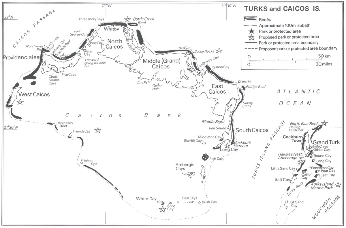

The waters around Providenciales are a Turks and Caicos historic wreck restricted area
The Protection of Historic Wrecks Ordinance of 1974 lets the Governor designate a restricted area round a wreck site. Two designations stand in the consolidated text, made under Legal Notice 29 of 1980 and Gazette Notice 132 of 1988. One is a circle of 500 yards centered on 21°48'10"N, 72°23'20"W. The other is a box: longitude 72°W to 72°30'W, latitude 21°N to 22°N.
That box is large. In DECR’s 2016 notice the Northwest Point corner sits at about 72°20'W, 21°52'N, the Princess Alexandra points run east to about 72°05'W, and the West Caicos points lie between 72°26'W and 72°30'W: all inside. The points the same notice gives for Grand Turk and South Caicos, east of 71°35'W, fall outside, and so does Salt Cay, which the map above shows beside Grand Turk on the Turks Bank.
The notice declares the vessels lying wrecked within these areas to be historic wrecks, and section 3 vests every historic wreck in the islands’ waters in the Crown. Inside a restricted area, section 4(3) makes it an offense, without the Governor’s license, to tamper with, damage or remove any part of a wreck or anything that came from it, or to drop anything that would cover the site, block access to it or damage it.
The penalties are heavier than anything in the park rules: on summary conviction $10,000 or two years, on indictment $50,000 or five years, and any vessel or machinery used is liable to forfeiture. Section 5 applies the same scale to anyone who deals in or possesses an object taken from a restricted area without a license.
One clause deserves a slow read. Section 4(3)(b) also covers anyone who “carries out diving or salvage operations directed to the exploration of any wreck”, or who “uses equipment constructed or adapted for any purpose of diving or salvage operations”. The 2016 regulations under the Ordinance deal only with archaeological survey and salvage licenses, and no government page reached for this guide says how the clause applies to a recreational diver visiting a wreck. Look, photograph and touch nothing.
The National Parks Order adds two named wreck sites. The Molasses Reef Wreck Area of Historical Interest is one acre south-east of West Caicos, described in the Order as the “Site of the oldest known wreck in the western hemisphere”. The HMS Endymion Wreck Area covers 6.5 acres south of Great Sand Cay, the wreck and everything within 100 yards of it, and regulation 3(4) bars taking any artifact there. Our wreck diving list covers coasts built around this kind of dive.
Spear guns and fish feeding are banned across Turks and Caicos fishery waters, not only in the parks
The Fisheries Protection Regulations apply throughout the islands’ fishery limits, and regulation 9 is the one a diver should read. It makes it an offense to use scuba equipment or any artificial breathing device other than a snorkel when taking marine products, unless a license is specifically endorsed for it, and to possess a spear gun anywhere within the fishing limits of the islands.
Regulation 11(2) is blunter: no spear gun on or within 50 feet of tidal water, on a beach or foreshore, while swimming or aboard any vessel. A Hawaiian sling, defined as a spear of up to six feet projected by elastic no longer than eighteen inches, is lawful only for holders of a commercial fishing license that permits finfish, or of a lionfish license. If you arrived planning to follow our spearfishing primer, the gun stays at home.
Regulation 9(1)(h) bans throwing any food into the water to feed, attract or harvest marine life unless the Director authorizes it, and 9(1)(i) bans breaking, removing or damaging coral anywhere in the fishery limits. Every item in regulation 9, and every item in regulation 11, carries a $50,000 fine or twelve months. A stingray or shark encounter that runs on food therefore needs the Director’s authority behind it.
Marine mammals get a regulation of their own. Regulation 26 says no person shall engage in fishing for, molest or otherwise interfere with any marine mammal. It carries no separate penalty, so regulation 47(2) applies: $5,000 or six months.
Turks and Caicos humpbacks arrive in late December and leave by early April, and DECR’s etiquette sets no distance
A 2023 paper in the Journal of Cetacean Research and Management puts humpback whales around the islands from late December to early April. They typically follow the Caicos Passage and the Turks Island Passage, moving west to east along the reef contour of the North Shore of the Caicos Bank early in the season. Whale watching here only began once humpbacks were being seen close to shore in the late 1990s.
The same paper is frank about how little is known. Research around the islands is “extremely limited”, and the older surveys that touched them reported low abundance. The Turks and Caicos Islands Whale Project, which set up its catalog with DECR under a scientific research permit in December 2021, had cataloged over 430 individuals by photo-identification. Read any seasonal headcount you see quoted for the passage against that.
The paper’s headline whale is a Caicos Bank story. TCI-36 was photographed on 21 February 2020 just west of Parrot Cay, where the reef drops off in roughly 19.8 meters (65 feet) of water, 88 days after being photographed in Skjálfandi Bay, Iceland, about 6,224 km away. It was back in the same bay 172 days later, the first documented round trip between Iceland and the Turks and Caicos.
The binding rule is regulation 26, which forbids molesting or interfering with a marine mammal but sets no approach distance. DECR’s whale-watching etiquette sheet sets none either. It asks boats to approach slowly and quietly, travel parallel rather than head-on, avoid fencing whales in or coming between mother and calf, and back off if whales change direction three to five times. Our whale watching list covers other places to see them.
.jpg)
Grand Turk and Salt Cay sanctuaries reach 400 feet out to sea, and entering one needs a permit
The Turks side runs under the same Order. Columbus Landfall Marine National Park covers 1,280 acres of sea off Grand Turk, from the high-water mark to the reef wall between the North Creek entrance and Boaby Rock Point, less an area cut out by a 2006 amendment. Grand Turk Cays Land and Sea National Park takes in Gibbs, Penniston and Martin Alonza Pinzon Cays and the 400 feet of sea around each.
Sanctuaries are stricter than parks. Long Cay Sanctuary, south-east of Grand Turk, and Big Sand Cay Sanctuary, south of Salt Cay with Little Sand Cay and nearby islets, both include the surrounding 400 feet of sea. Regulation 3(3)(a) prohibits public access to a sanctuary without the Director’s prior written approval on form NP1, and section 7 of the Ordinance makes entering one without authority a $50,000 offense.
On the Caicos side the equivalent is drawn differently. The French, Bush and Seal Cays Sanctuary is defined as the entire land area of French Cay, south of West Caicos, and of Bush Cay and the Seal Cays south of South Caicos. Unlike Long Cay and Big Sand Cay, no band of sea is written into it, so the permit rule reads on the cay itself rather than on the water around it. Salt Cay’s own Area of Historical Interest includes Whale Island and Whale House Bay.
South Caicos lost 62 percent of its monitored coral cover after the 2019 Turks and Caicos disease outbreak
Stony coral tissue loss disease was first documented in the Turks and Caicos Islands in 2019, according to a 2021 paper in Coral Reefs. On permanent transects on the South Caicos fore reef, coral cover held steady from 2012 to 2018 at a mean of 2.97 percent, then fell to 1.14 percent in 2020, a 62 percent loss. Three susceptible groups, Dichocoenia, Eusmilia fastigiata and Meandrina meandrites, were absent from every survey for the first time.
That study measured South Caicos, not Providenciales. One account of the spread comes from the Turks and Caicos Reef Fund, the nonprofit that ran treatment trials: it reports the disease first on the reefs of South Caicos and West Caicos in early 2019, then off Northwest Point and Grace Bay, then eastward past Pine Cay to reefs off Middle and North Caicos.
The fund reports that amoxicillin in an ointment base, pressed into the edge of a lesion, was nearly 90 percent effective at stopping progression in trials that began in early 2020, and that it filed its final report with DECR. Those figures are the fund’s own account.
Turks and Caicos hurricane season peaks in September, the month Irma and Maria passed in 2017
NOAA’s National Hurricane Center sets the Atlantic season at 1 June to 30 November, with a peak around 10 September and most activity between mid-August and mid-October.
2017 showed what the peak can do. The center’s report on Irma says its eye passed just south of the islands around 00:00 UTC on 8 September, with the northern eyewall passing near or over them. Providenciales, including its hospital, was heavily damaged. No deaths occurred, and damage was estimated at at least 500 million US dollars. The observing equipment on the islands failed, so the report has no measurements from them for that night.
Two weeks later Maria’s center passed 30 to 40 nautical miles east and north-east of the islands on 22 September, and a station at Grace Bay logged sustained winds of 41 knots with a 48-knot gust. If you plan to dive here between August and October, read the trip-interruption terms of your cover as closely as the dive terms; the watersports insurance explainer goes through what each kind of policy leaves out.
The Providenciales recompression chamber is run by a private practice on Leeward Highway
The recompression chamber on Providenciales belongs to Associated Medical Practices, a private practice in the Menzies/Bourne Building at 5A Windward Road, Leeward Highway. Its own page says the chamber has treated more than 400 divers on the island, that treatment follows US Navy protocols, and that its physicians have formal training in decompression sickness. It warns that treatment can be costly, and lists a 24-hour emergency doctor line on +1 649 432 2111.
The public hospital, the Turks and Caicos Islands Hospital, lists its Providenciales site at Cheshire Hall on +1 (649) 941-2800 and a second site in Cockburn Town, Grand Turk, on +1 (649) 941-2900. Its departments page lists emergency, imaging and other services but no hyperbaric unit. Divers Alert Network’s instruction is to contact local emergency services first, then call DAN on +1-919-684-9111.
Chamber time is billed like any other treatment, which is what the dive insurance comparison is for. Check a policy’s chamber and evacuation limits before the first dive, not after it.
Four Providenciales dive businesses in the registers, and the tourism license required since 2023
The Providenciales operator list holds 4 dive businesses. Three are published by SSI in its register of affiliated training centers, checked on 20 September 2026: Aqua TCI, Dive Provo and the Turks and Caicos Aggressor II, which SSI rates for Freediving. The fourth, Turks & Caicos Explorer II, is a Green Fins digital member, read on 21 September 2026 and self-evaluated rather than assessed in person. All four publish a website.
A register entry is a membership, not a license. The license is a separate document: since 27 November 2023 the Tourism Regulation and Licensing Ordinance has required a tourism services license for anyone offering the services it lists, water sport and tour boats among them, with a $2,500 fine for offering them without one. Section 30 tells the Director to keep registers of tourism services.
No public version of that register was found for this guide, so ask the operator for its tourism license and, inside a park, for the regulation 7 vessel license that has to be carried aboard. Which registers can be read logs what each source returned when we went looking.
FAQ: scuba diving in Turks and Caicos
Do you need a permit to dive in the Turks and Caicos national parks?
Not as an individual diver. Regulation 7 of the National Parks Regulations puts the license on the dive or charter vessel, issued for six or twelve months for a named park, and the park fee in regulation 11 is charged to the dive operator per diver and dive site, in arrears. Sanctuaries differ: entering Long Cay or Big Sand Cay Sanctuary, including the 400 feet of sea around them, needs the Director's prior written approval.
When is humpback whale season in Turks and Caicos?
A 2023 paper in the Journal of Cetacean Research and Management puts humpbacks around the islands from late December to early April, typically following the Caicos Passage and the Turks Island Passage. The paper calls research around the islands extremely limited, and the Turks and Caicos Islands Whale Project had cataloged over 430 individuals. Regulation 26 of the Fisheries Protection Regulations forbids molesting or interfering with any marine mammal.
Is spearfishing allowed in Turks and Caicos?
Not with a spear gun. The Fisheries Protection Regulations make possessing a spear gun anywhere in the fishing limits an offense, and bar one within 50 feet of tidal water, on a beach, while swimming or aboard a vessel, each liable to a $50,000 fine. A Hawaiian sling is lawful only with a commercial license that permits finfish or a lionfish license, and scuba may not be used to take marine products.
Where is the recompression chamber in Turks and Caicos?
On Providenciales, run by Associated Medical Practices, a private practice at 5A Windward Road, Leeward Highway. Its page says the chamber has treated more than 400 divers and follows US Navy protocols, and lists a 24-hour emergency doctor line on +1 649 432 2111. The public hospital's Providenciales site at Cheshire Hall is on +1 (649) 941-2800, and DAN's emergency line is +1-919-684-9111.
Can you take anything from a shipwreck in Turks and Caicos?
No. The Protection of Historic Wrecks Ordinance vests historic wrecks in the Crown, and a restricted area running from 72 to 72 degrees 30 minutes west and 21 to 22 degrees north covers Providenciales and West Caicos. Removing or damaging any part of a wreck there without the Governor's license carries up to $10,000 or two years on summary conviction and $50,000 or five years on indictment.
Note: Conditions, safety guidance and regulations change. Verify current information with official sources, including the dive operator, the park authority and the relevant government department, before you travel or dive.
Founder of NOMADREEF and a former digital nomad. This guide is sourced from the references below; conditions, prices and rules change, so verify current details, and follow qualified local guidance and safety briefings. About the author · LinkedIn ↗
Sources
- The parks, their areas and the rules inside them. Primary source. National Parks Ordinance, Chapter 10.01, revised edition showing the law as at 31 March 2018, published by the Attorney General’s Chambers among the 2021 revised laws: section 3(4) to (6) on the Gazette notice, six weeks of representations and House of Assembly approval of a draft order; section 7 on the $50,000 or twelve-month penalty for entering a sanctuary without authority. National Parks Order, Schedule Parts I to IV: Northwest Point Marine National Park (2,535 acres), Princess Alexandra Land and Sea National Park (6,532 acres), West Caicos Marine National Park (980 acres, “Excellent wall diving”), Fort George Land and Sea National Park (1,220 acres), Columbus Landfall Marine National Park (1,280 acres, amended by Legal Notice 3 of 2006), Grand Turk Cays Land and Sea National Park, Long Cay, Big Sand Cay and French, Bush and Seal Cays Sanctuaries, and the Molasses Reef, HMS Endymion and Salt Cay Areas of Historical Interest. National Parks Regulations: regulation 2 on the fixed DOE buoy and the fifty-fathom wall; regulation 3(1), (2), (3), (4), (5) and (6); regulation 5 on emergencies and hurricane warnings; regulation 6 and Schedule 2 on the zones from Babaloo Beach to Leeward-Going-Through Point; regulation 7 on dive vessel licenses; regulation 9(1)(c) on the 300-foot rule; regulations 11 and 12 on fees and monthly returns; regulation 14 on the $50,000 and $5,000 tiers. National Parks (Fees) Notice, Legal Notice 24 of 2011. Chapter 10.01, National Parks Ordinance and subsidiary legislation (PDF). Read 24 September 2026. The fee amounts in the 2011 schedule do not line up with their rows in the consolidated text, so no amount is quoted here.
- Changes since the consolidation. Primary sources. National Parks (Amendment) Regulations 2018, Legal Notice 25 of 2018, adding Half Moon Bay Channel to the established navigational channels: LN 25/2018 (PDF). DECR, Notice of Changes to the National Parks Order under section 3(4), 2016, with the proposed areas for Northwest Point (4,170.52 acres), Princess Alexandra (13,410.82 acres) and West Caicos (2,769.3 acres) and the coordinates used above for the box comparison: signed notice (PDF). Both read 24 September 2026. No amending National Parks Order appears in the Attorney General’s annual lists of subsidiary legislation for 2018 to 2026 as read that day; whether the 2016 boundaries have been adopted is a gap.
- DECR’s visitor guidance. Primary source for what the department asks, not law. Essential Information for Visitors and Residents, Providenciales: the 300-foot rule, anchoring in clear sand, the Grace Bay access lanes with red and green markers, white swimming buoys and biodegradable sunscreen: leaflet (PDF). Whale Watching Etiquette: sheet (PDF). Both linked from DECR, Rules and Etiquette. Read 24 September 2026.
- The common version of the fine. Secondary source, quoted as the claim corrected above: “Fishing is strictly prohibited in all protected areas, with fines of $50,000 per infraction.” Visit Turks and Caicos Islands, National Parks. Read 24 September 2026.
- Spear guns, scuba harvesting, fish feeding and marine mammals. Primary source. Fisheries Protection Ordinance, Chapter 10.08, revised edition showing the law as at 31 March 2021: Fisheries Protection Regulations, regulation 2 definitions of Hawaiian sling and spear gun; regulation 6(o) on the lionfish license; regulation 9(1)(c), (d), (f), (h) and (i) and 9(2) with its $50,000 or twelve-month penalty; regulation 11(2) and (4); regulation 26 on marine mammals; regulation 47(2) on the $5,000 or six-month general penalty. Chapter 10.08 (PDF). The Fisheries Protection (Amendment) Regulation 2023, Legal Notice 33 of 2023, amends regulations 4, 5, 7, 8 and 30 and the schedules, not the regulations cited here: LN 33/2023 (PDF). Read 24 September 2026.
- The wreck restricted area. Primary source. Protection of Historic Wrecks Ordinance, Chapter 10.03, revised edition showing the law as at 31 March 2018: section 2 definition of historic wreck; section 3 vesting in the Crown; section 4(3) and (6); section 5; the restricted areas under section 4 made by Legal Notice 29 of 1980 and Gazette Notice 132 of 1988, the box from 72°W to 72°30'W and 21°N to 22°N and the 500-yard circle at 21°48'10"N 72°23'20"W; the Protection of Historic Wrecks Regulations, Legal Notice 41 of 2016, on survey and salvage licenses. Chapter 10.03 (PDF). Read 24 September 2026. Which of the two areas each notice created is not stated in the consolidation. How section 4(3)(b) applies to recreational diving on a wreck is a gap: no government guidance on it was found.
- The arrival fee. Primary sources. Destination Management Fee Ordinance 2023, Ordinance 12 of 2023, sections 3, 4, 5, 12 and 13 and Schedules 1 and 2: Ord. 12/2023 (PDF); commencement on 27 November 2023 by Legal Notice 75 of 2023: LN 75/2023 (PDF); Destination Management Fee (Amendment) Act 2026, Act 4 of 2026, published 16 March 2026, on crew, children under two and transit of up to three hours: Act 4/2026 (PDF); Destination Management Fee (Amendment) (No. 2) Act 2026, Act 14 of 2026: Act 14/2026 (PDF). Read 24 September 2026. The $10 is the Schedule 1 amount as enacted; no order amending it appears in the annual lists as read that day.
- The tourism license. Primary sources. Tourism Regulation and Licensing Ordinance 2023, Ordinance 13 of 2023, section 23 on the license and the $2,500 fine, section 30 on registers of tourism services, section 75 on the six-month transition, and Schedule 4 listing water sport and tour boat operators: Ord. 13/2023 (PDF); commencement on 27 November 2023 by Legal Notice 76 of 2023: LN 76/2023 (PDF); the Tourism Authority Act 2026, section 56, amending it: Act 10/2026 (PDF). Read 24 September 2026.
- The humpbacks. Primary source, peer reviewed. Bacon CE, Hart KA, Cheeseman T, Munson L, Rasmussen MH, Chosson V, Basran CJ (2023), Short Communication: First documented humpback whale (Megaptera novaeangliae) photo-identification match and round-trip migration between Iceland and the Turks and Caicos Islands, Journal of Cetacean Research and Management 24, 161: late December to early April; the Caicos Passage, the Turks Island Passage and the North Shore of the Caicos Bank; whale watching beginning in the late 1990s; research “extremely limited”; the catalog established in December 2021 with DECR and over 430 individuals; TCI-36 off Parrot Cay on 21 February 2020 in roughly 19.8 m, 88 days and about 6,224 km from Skjálfandi Bay, and back 172 days later. JCRM article 405. Read 24 September 2026. Seasonal headcounts for the passage repeated on tourism sites were not used: the paper gives none.
- The coral disease. Primary source, peer reviewed, read in its published abstract. Heres MM, Farmer BH, Elmer F, Hertler H (2021), Ecological consequences of Stony Coral Tissue Loss Disease in the Turks and Caicos Islands, Coral Reefs 40, 609–624: first documented in 2019; South Caicos fore reef cover 2.97 percent (mean 2012 to 2018) against 1.14 percent in 2020, a 62 percent loss; three taxa absent for the first time. doi:10.1007/s00338-021-02071-4. Secondary source for the spread and the treatment, the organization’s own account: Turks and Caicos Reef Fund, 19 April 2021. Both read 24 September 2026. The fund’s pages give the number of affected coral species as over 20 on one page and approximately 30 on the other, so no count is stated.
- Hurricanes. Primary sources. NOAA National Hurricane Center, Tropical Cyclone Climatology: the season from 1 June to 30 November, peak on 10 September, most activity mid-August to mid-October: NHC climatology. Cangialosi JP, Latto AS, Berg R, Tropical Cyclone Report, Hurricane Irma (AL112017): the eye passing just south around 0000 UTC 8 September, the northern eyewall, failed observing equipment, damage to Providenciales and its hospital, no deaths, at least 500 million USD: AL112017 (PDF). Pasch RJ, Penny AB, Berg R, Tropical Cyclone Report, Hurricane Maria (AL152017): center 30 to 40 n mi east and north-east on 22 September; Grace Bay 41 kt sustained, 48 kt gust: AL152017 (PDF). All read 24 September 2026.
- Emergency care. Primary sources, each for its own service. Associated Medical Practices, Hyperbaric Chamber: more than 400 divers treated, US Navy protocols, trained physicians, cost warning, address and 24-hour line: doctorstci.com. Turks and Caicos Islands Hospital, contact and departments pages: contact, departments. Divers Alert Network: “In an emergency, contact local EMS, then call DAN at +1-919-684-9111”: DAN medical services. All read 24 September 2026. A chamber at the hospital’s Cheshire Hall site could not be confirmed from the hospital’s own pages, so none is claimed.
- The four businesses. Four dive businesses on the Providenciales operator list: three published by SSI in its register of affiliated centers, checked 20 September 2026, one of them rated for Freediving; one Green Fins digital member, read 21 September 2026, self-evaluated. All four publish a website. The limits of each source are set out on which registers can be read.
- Not covered. Entry and length-of-stay rules for remote workers: the Border Force visas and permits page, read 24 September 2026, describes work permits and extensions but no remote-work route, and no other primary source was found, so the guide makes no statement on it. A conservation fund or environmental levy paid by visitors: the Hotel, Restaurant and Tourism (Taxation) Ordinance as at 31 March 2021 was searched and provides none, and the only arrival charge found is the destination management fee above.