Key Largo vs Key West for Diving and Snorkeling: Which Base?
 by Yannick SchrothOct 13, 202612 min read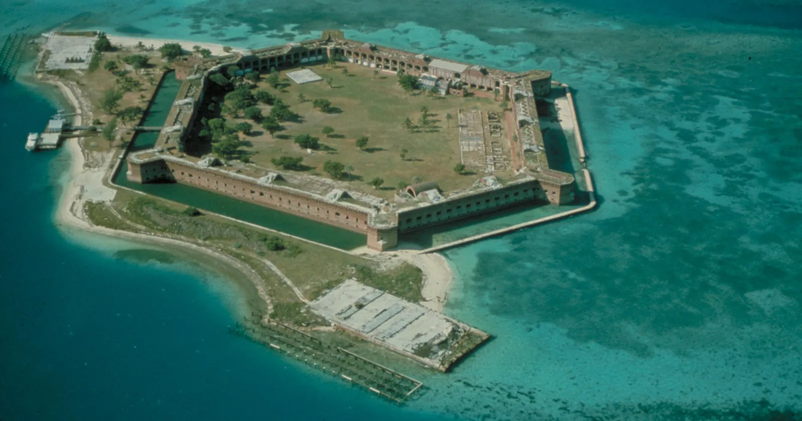
Fort Jefferson on Garden Key, Dry Tortugas National Park, about 70 miles west of Key West: the Key West side of this comparison. An NPS archive slide; NPGallery dates it November 2003. Photo: NPS, Wikimedia Commons, public domain, cropped.
| Key Largo | Key West | |
|---|---|---|
| Signature reefs | Molasses, The Elbow, Carysfort, Key Largo Dry Rocks with the Christ of the Deep statue | Sand Key, Rock Key, Eastern Dry Rocks; Looe Key up the road |
| Whose rules apply on those reefs | Federal water: the 2025 sanctuary rule, with an anchoring ban in preservation areas from 19 January 2027 | Florida state water: the 1997 sanctuary rules, no 2027 anchoring ban |
| Big wreck | Spiegel Grove, 135 ft | Vandenberg, 145 ft |
| Shallow wrecks on NOAA's Shipwreck Trail | Benwood, 25 to 45 ft; City of Washington, 25 ft | Amesbury, under 30 ft |
| Snorkeling from the beach | Cannon Beach in Pennekamp, with Spanish shipwreck artifacts 100 ft out | Fort Zachary Taylor, a rocky beach beside the main shipping channel |
| Spearfishing | Banned by state law down to Long Key, and spearguns banned in the federal management area | Neither ban applies; preservation areas are no-take |
| Dry Tortugas | Drive to Key West first | Ferry at 08:00, back 17:15; no scuba tanks aboard |
| Water, February average | 23.5°C (74.3°F) at Molasses Reef | 22.7°C (72.9°F) at Sand Key |
| Hospital-based hyperbaric chamber | Mariners Hospital, Tavernier | The same one, at the other end of US 1 |
Rules, schedules and fees as of October 2026. Water figures are NOAA buoy-station averages; the periods and the caveats are in the water section below.
Key Largo's reefs are federal water, Key West's are state water, and the rules split there
This is the difference that matters most in Key Largo vs Key West, because it changes what a dive boat may do on the reef. Both towns dive the Florida Keys National Marine Sanctuary. NOAA rewrote the sanctuary's regulations in a final rule published on 17 January 2025 (90 FR 6104). On 3 March 2025 Governor Ron DeSantis certified that rule unacceptable, so it does not take effect in the part of the sanctuary that lies in Florida's state waters.
NOAA's own zone data, revised on 28 April 2026, settles which side each reef is on. Molasses Reef, The Elbow and the 146.9-square-mile Key Largo Management Area are marked “Within_State_Waters: No”. Sand Key, Rock Key and Eastern Dry Rocks off Key West are marked Yes. So the new rule governs Key Largo's reefs, and the 1997 rules still govern Key West's.
The practical result arrives on 19 January 2027. From that date the 2025 rule bans anchoring by any means in every Sanctuary Preservation Area. NOAA's preservation area page, read again on 13 October 2026, lists six exceptions: Hen and Chickens, Cheeca Rocks, Newfound Harbor Key, Eastern Dry Rocks, Rock Key and Sand Key. All three Key West areas are on it, and none of the Key Largo ones. Off Key West the 1997 wording keeps applying instead: no anchor on coral, and none when a mooring buoy is free.
One oddity follows from the split. The 2025 rule eliminated Rock Key as a preservation area, which would have reopened it to fishing, but the change does not reach state water, so NOAA still lists Rock Key SPA. No Federal Register notice announcing the rule's effective date had appeared by 13 October 2026. The full reading is in the Key Largo diving guide and the Key West diving guide.
Spiegel Grove vs Vandenberg: the big wrecks off Key Largo and Key West are both deep
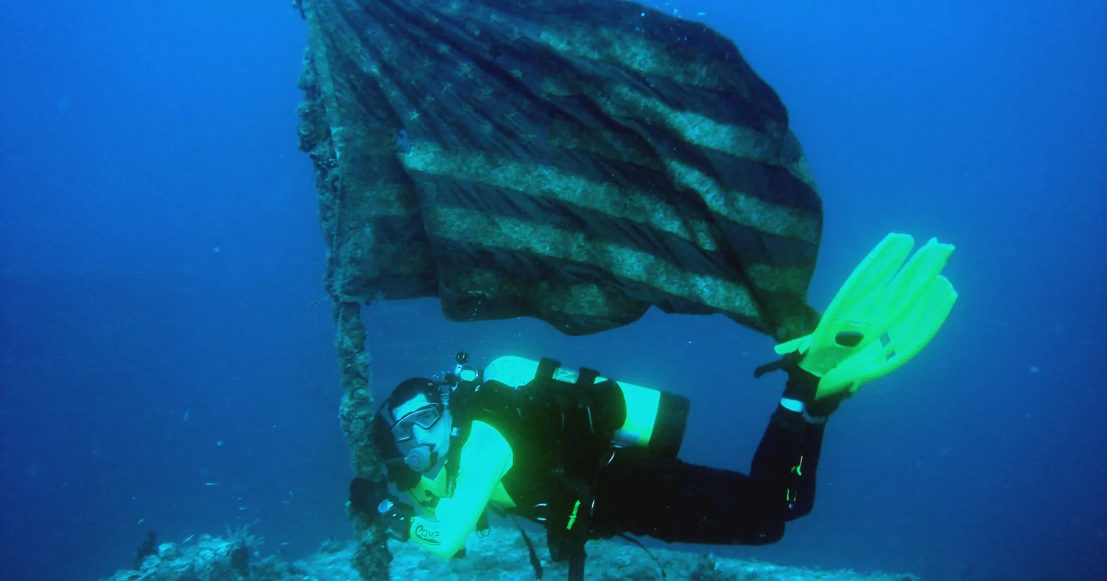
Each town has one headline wreck, and both sit deeper than 130 feet at the sand. The Florida Fish and Wildlife Conservation Commission files the Spiegel Grove, a 510-foot former Navy landing ship, in 135 feet of water off Key Largo with 84 feet of relief, deployed on 17 May 2002. It files the General Hoyt S. Vandenberg, a 522-foot former missile tracking ship, in 145 feet of water off Key West with 100 feet of relief, deployed on 27 May 2009.
The difference is what sits around them. Key Largo has two more deep wrecks, the Coast Guard cutters Duane and Bibb, filed at 118 and 130 feet. It also has the shallow ones. NOAA's Shipwreck Trail puts the Benwood, a British freighter, in 25 to 45 feet between French Reef and Dixie Shoals, and the City of Washington, an iron-hulled steamship, in 25 feet on Elbow Reef. Key West's shallow trail wreck is the Amesbury, an artificial reef 5 miles west of town in less than 30 feet. The state files Joe's Tug, near the Vandenberg, at 65 feet.
NOAA studied both sinkings and found opposite results. Its summary says the Vandenberg, “unlike the Spiegel Grove, did not reduce user pressure on the surrounding natural reefs”. Off Key West, total use rose on both. For someone counting on the big wreck to empty the reef, Key Largo has the better record. Gas planning at these depths is its own topic; the nitrox explainer covers what a mix changes.
Key Largo vs Key West beaches for snorkeling: Cannon Beach or Fort Zach
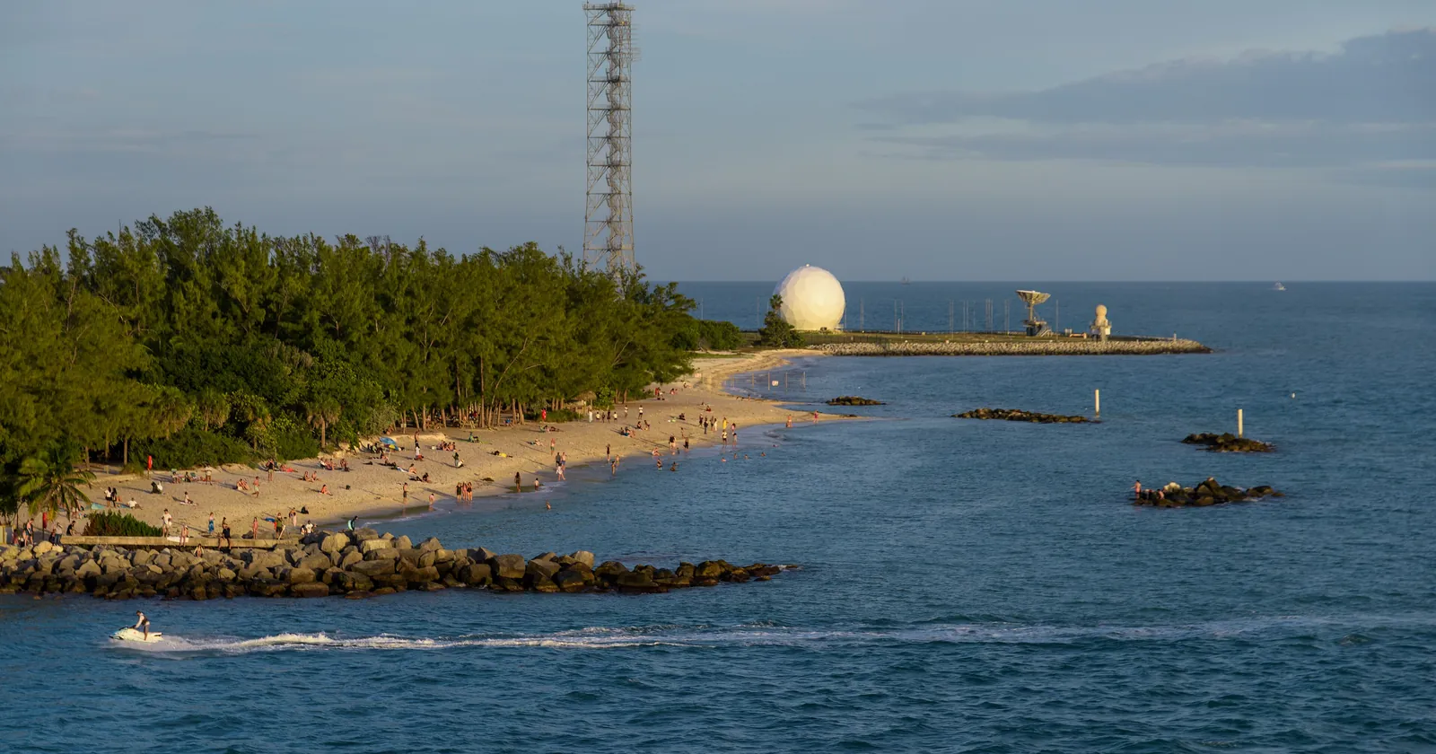
The best-known beach in each town belongs to a state park, and both parks are frank about it. John Pennekamp Coral Reef State Park in Key Largo has “two human-made beaches”. Cannon Beach is its snorkeling beach, with artifacts from an early Spanish shipwreck placed about 100 feet offshore. Swimming or snorkeling outside the designated areas needs a diver-down flag. Entry is $8 per vehicle plus 50 cents a person for up to eight people, and the park is open 8 a.m. to sunset every day.
The real reef is a boat ride out. The park says three reef systems lie offshore, the closest about 300 yards out and the last more than two miles. Its concession runs snorkel boats four times a day, each 2.5 hours with about 1.5 hours on the reef, and four-hour, two-tank dive trips. One park rule surprises visiting divers: dives must be completed one hour before sunset, so there is no night diving under the park's rules.
Fort Zachary Taylor Historic State Park in Key West says it offers some of the best snorkeling from the beach in the Keys, “good for beginners”. Read the rest of the page too. Locals call it “rocky beach”, water shoes are recommended, no lifeguards are on duty, and the park sits next to the main shipping channel, whose currents it credits for the clear water. Entry is $6 per vehicle. Without a boat, Fort Zach is the easier way to fish from the shore; in Key Largo the reef starts with a boat ride.
The Dry Tortugas are a Key West day trip, but your scuba tanks stay behind
Dry Tortugas National Park lies about 70 miles west of Key West, with no road. This is the one thing Key West can sell that Key Largo cannot. The park's authorized ferry, the Yankee Freedom, leaves from 100 Grinnell Street at 08:00, reaches Fort Jefferson at 10:15, leaves again at 15:00 and docks in Key West around 17:15. Snorkel gear and the $15 park entrance fee are included in the ticket.
Scuba is another matter. The park states that the ferry and seaplane “are unable to carry compressed canisters aboard”, and the ferry lists compressed gas among the things not to bring. To dive the Tortugas you need your own boat or a charter vessel. A private boat whose occupants dive, snorkel or use the park's mooring buoys also needs a permit from the superintendent under 36 CFR 7.27(h), which the rule allows to be given by radio or telephone.
From Key Largo, the ferry's 07:00 check-in means a night in Key West first. For a snorkeler, though, the ferry day alone may decide this comparison.
Spearfishing: banned around Key Largo by two rules that stop short of Key West
For spearfishers the Key Largo vs Key West question has a short answer. Florida Statutes section 379.2425 prohibits spearfishing in Pennekamp and in the Upper Keys, defined as all salt water under the state wildlife commission's jurisdiction from the Miami-Dade line south “down to and including Long Key”. Beyond the state line, the sanctuary bans “fishing with, carrying or possessing” spearguns, pole spears and Hawaiian slings in the Key Largo Management Area. The same federal ban covers the small Looe Key Management Area.
Key West's reefs sit outside both lines. Spearfishing there follows the state's general rules and the sanctuary's zones: the preservation areas at Sand Key, Rock Key and Eastern Dry Rocks, and the Western Sambo Ecological Reserve, are no-take for everyone. West of Sand Key, Florida closes Western Dry Rocks to fishing and to possessing fish from 1 April to 31 July, and its stowage clause covers spear gear. Diving there is not restricted.
Key Largo vs Key West water temperature, and the hurricane months they share
NOAA's National Data Buoy Center ran weather stations on the reef at both ends: Molasses Reef off Key Largo and Sand Key off Key West. Its climatic summaries give the monthly mean sea temperature for each.
| Month | Molasses Reef, Key Largo | Sand Key, Key West |
|---|---|---|
| January | 23.8°C (74.8°F) | 23.0°C (73.4°F) |
| February | 23.5°C (74.3°F) | 22.7°C (72.9°F) |
| April | 25.2°C (77.4°F) | 24.9°C (76.8°F) |
| June | 28.5°C (83.3°F) | 28.7°C (83.7°F) |
| August | 30.0°C (86.0°F) | 30.1°C (86.2°F) |
| October | 28.1°C (82.6°F) | 28.0°C (82.4°F) |
| December | 24.8°C (76.6°F) | 24.4°C (75.9°F) |
In the Key Largo vs Key West water comparison, the gap is a winter one. From December to February the water at Molasses averaged 0.4 to 0.8°C warmer than at Sand Key; from June to October the two are within 0.2°C. Treat these as long-run averages, not this year's water. The Molasses figures cover December 1987 to December 2008 and the Sand Key figures May 1991 to September 2005, and neither station has reported a water temperature to the data center since early 2019. The 2023 summer ran far above them: NOAA's sanctuary recorded warm water from February that year and called it the longest-lasting marine heat wave in the region since 1991.
Storm season does not split. The National Hurricane Center gives the Atlantic season as 1 June to 30 November, with a peak on 10 September and most activity from mid-August to mid-October. Both towns sit on the same chain of islands, on the same road out. For a stay of weeks in that window, book something you can leave on short notice.
Coral after 2023: Key Largo's outer reefs ran cooler, Key West kept its elkhorn
A study published in December 2024 called the summer 2023 heat wave “the most severe on record for Florida's Coral Reef”. It tracked brain and boulder corals at nine reefs from Sand Key to Carysfort. At seven of the nine, only 0 to 2% of the tracked colonies suffered any mortality, and both towns' outer reefs were in that group. The two badly hit sites were inshore, Newfound Harbor and Cheeca Rocks, with 43% and 30% of monitored corals dead. On temperature, the authors found Grecian/Key Largo Dry Rocks and Carysfort “consistently the coolest” of their sites.
The branching corals tell a different story. Seven reefs are NOAA's Mission: Iconic Reefs restoration sites, among them Carysfort and Horseshoe off Key Largo and Eastern Dry Rocks off Key West. After the heat, a NOAA survey found less than 22% of about 1,500 outplanted staghorn corals alive, and only at Carysfort and Horseshoe. Live elkhorn turned up at three sites, Carysfort, Sombrero and Eastern Dry Rocks. Expect restoration work on both sides, not untouched reef.
The Florida Keys hyperbaric chamber is near Key Largo, a long way from Key West
Baptist Health says Mariners Hospital, at 91500 Overseas Highway in Tavernier, is “home to the only hospital-based hyperbaric chamber in the Florida Keys”, used for diving injuries. The hospital runs a 24-hour emergency department with an on-site helipad. Tavernier sits at the southern end of Key Largo, so a Key Largo diver is close to it.
For Key West that chamber is at the far end of US 1. Lower Keys Medical Center in Key West offers 24-hour emergency care, and its services list does not include hyperbaric medicine. The route from any boat is the same: Divers Alert Network tells divers to call 911 first in a life-threatening emergency, then its emergency line on +1-919-684-9111. Check that your dive insurance pays for an air transfer as well as the treatment.
The road itself is long. Florida State Parks puts the Overseas Heritage Trail corridor from Key Largo to Key West at 106 miles, and the state's scenic highway program gives the Keys byway on US 1 as 110 miles from Key Largo. Key West has its own airport, Key West International; Key Largo is the end of the chain nearest Miami.
Key Largo and Key West dive shops on our lists
Both lists are small, and each reaches well beyond the town in its name.
| Key Largo | Key West | |
|---|---|---|
| Dive businesses on our list | 7 | 6 |
| Listed by SSI, with an entry you can open | 6 | 5 |
| Green Fins digital members (self-evaluated) | 2 | 1 |
SSI files four of the Key Largo entries in Key Largo itself, one in Tavernier and one in Islamorada. Of the Key West five, only two are filed in Key West; the others sit in Big Pine Key, Ramrod Key and Summerland, closer to Looe Key than to Sand Key. The Key Largo operator list and the Key West operator list name them. These are membership registers, not licenses, and a Green Fins digital membership is a self-evaluation rather than an in-person assessment of the shop.
Key Largo vs Key West in five lines
- Key Largo's reefs are federal water under the 2025 rule, with a preservation-area anchoring ban from 19 January 2027; Key West's stay under the 1997 rules.
- Both big wrecks are deep: Spiegel Grove 135 ft, Vandenberg 145 ft. Key Largo has the shallow trail wrecks too.
- The Dry Tortugas are Key West's alone, by ferry for snorkelers and by private boat or charter for divers.
- Spearfishing is banned around Key Largo by state law and federal rule; neither ban reaches Key West.
- The Keys' only hospital-based chamber is in Tavernier, at the Key Largo end of US 1.
Key Largo for reef mornings, Key West for the Tortugas and its own airport
Base in Key Largo if you want to dive often on reefs a short ride out, if you want shallow wrecks alongside the Spiegel Grove, or if a chamber within reach matters to you, as it should on a month of deep wreck dives. Winter water runs a little warmer there. Do not come to spearfish.
Base in Key West if the Dry Tortugas are on your list, if you spearfish, or if you want an airport on the island. At Sand Key, boats may still anchor after January 2027 under the 1997 rules, though not on coral and not when a buoy is free. For a long stay, Key Largo vs Key West need not be either/or: a month at each end, with Looe Key in between, covers the reef line. The Miami diving guide covers the stretch north of Key Largo.
FAQ: Key Largo vs Key West
Is Key Largo or Key West better for scuba diving?
Key Largo for frequent reef diving: Molasses, The Elbow and Carysfort are its home reefs, and it has shallow wrecks such as the Benwood and City of Washington as well as the 135-foot Spiegel Grove. Key West for the 145-foot Vandenberg and dive charters to the Dry Tortugas. The only hospital-based hyperbaric chamber in the Keys is in Tavernier, near Key Largo.
Key Largo vs Key West beaches: which is better for snorkeling from shore?
Fort Zachary Taylor in Key West, if you want fish from the shore: the park calls it some of the best beach snorkeling in the Keys, over a rocky bottom beside the shipping channel. Pennekamp in Key Largo has two human-made beaches; Cannon Beach has Spanish shipwreck artifacts 100 feet out, but the reefs are a boat ride away.
How far is Key Largo from Key West?
About 106 to 110 miles on US 1, the only road. Florida State Parks gives the Overseas Heritage Trail corridor from Key Largo to Key West as 106 miles, and the state's scenic highway program puts the Keys byway at 110 miles from Key Largo. The Dry Tortugas are another 70 miles west of Key West, by boat or seaplane.
Can you scuba dive the Dry Tortugas on a day trip from Key West?
Not on the ferry. The National Park Service says the ferry and seaplane cannot carry compressed canisters, so divers need their own boat or a charter vessel. A private boat whose occupants dive or snorkel needs a superintendent's permit under 36 CFR 7.27, which can be given by radio. The Yankee Freedom ferry suits snorkelers: 08:00 out, about 17:15 back.
Key Largo vs Key West vs Islamorada: where does Islamorada fit for diving?
Between the two, and on the Key Largo side of the rules. Florida's spearfishing ban runs down to Long Key, past Islamorada. Cheeca Rocks, the inshore reef off Upper Matecumbe Key, is a restoration site and one of the two worst-hit sites in a study of the 2023 heat, with 30% of monitored corals dead. One SSI-listed Key Largo business is filed in Islamorada.
Note: Sanctuary rules in the Keys are in flux, and the 2027 anchoring date may still move. Check the zone you plan to dive with NOAA and your boat, and follow the briefing on board.
Sources
- The 2025 sanctuary rule, its non-effect in state waters on the governor's certification, and the delay of the anchoring provisions to 19 January 2027. NOAA, 90 FR 6104, 17 January 2025, federalregister.gov. The governor's letter of 3 March 2025, in the copy published by Bonefish & Tarpon Trust (PDF). No effective-date notice found in a Federal Register search for the sanctuary run on 13 October 2026.
- Which reefs lie in state waters. NOAA, FKNMS Zone Boundaries with Attributes, 28 April 2026, queried 13 October 2026: Molasses Reef SPA, The Elbow SPA, Looe Key SPA, Key Largo Management Area (146.9 sq mi) and Looe Key Management Area “No”; Sand Key, Rock Key and Eastern Dry Rocks SPAs “Yes”.
- The 2027 anchoring exceptions and the SPA list, including Rock Key. NOAA, Sanctuary Preservation Areas, read 13 October 2026. The statue at Key Largo Dry Rocks: Key Largo Dry Rocks-Grecian Rocks SPA; Cheeca Rocks southeast of Upper Matecumbe Key: Cheeca Rocks SPA.
- The wrecks: Spiegel Grove (510 ft, 135 ft deep, 84 ft relief, 17 May 2002), Hoyt Vandenberg (522 ft, 145 ft, 100 ft relief, 27 May 2009), Duane (118 ft), Bibb (130 ft), Joe's Tug (65 ft). Florida Fish and Wildlife Conservation Commission, Artificial Reef Locations in Florida, queried 13 October 2026.
- Benwood, City of Washington and Amesbury depths. NOAA, Florida Keys Shipwreck Trail, read 13 October 2026.
- The two wreck studies: the Vandenberg, “unlike the Spiegel Grove, did not reduce user pressure on the surrounding natural reefs”. NOAA, New Artificial Reefs, read 13 October 2026.
- John Pennekamp Coral Reef State Park: beaches, Cannon Beach artifacts, flag rule, three reef systems, boat trips, dive rules (one hour before sunset, no lights for Open Water divers). Florida State Parks, Experiences & Amenities, read in the Internet Archive copy of 23 September 2026, because the live site refuses automated requests. Fees and hours: Hours & Fees, copy of 7 February 2026. Read 13 October 2026.
- Fort Zachary Taylor Historic State Park: snorkeling “good for beginners”, rocky beach, water shoes, no lifeguards, the shipping channel, and $6 per vehicle. Florida State Parks, read in Internet Archive copies of the park page, 21 September 2026, and Experiences & Amenities, 14 February 2026. Read 13 October 2026.
- Dry Tortugas National Park: about 70 miles west of Key West, Directions (updated 25 September 2026); no compressed canisters on the ferry or seaplane, Swimming, Snorkeling, and Diving; $15 per person, included in ferry tickets, Fees & Passes; the private-vessel permit and oral permits, 36 CFR 7.27. Read 13 October 2026.
- Yankee Freedom ferry schedule: 08:00 departure from 100 Grinnell Street, 10:15 arrival, 15:00 departure, 17:15 return, snorkel gear included, no compressed gas canisters. The operator's own page, read in the Internet Archive copy of 21 September 2026 because the live site refused automated requests on 13 October 2026.
- Spearfishing: Florida Statutes 379.2425 (Pennekamp and the Upper Keys “down to and including Long Key”); 15 CFR 922.164(b) (spearguns in the Key Largo and Looe Key Management Areas); Western Dry Rocks, Florida rule 68B-6.004. Read 13 October 2026.
- Sea temperature: NOAA National Data Buoy Center climatic summaries, monthly mean sea temperature, Molasses Reef (MLRF1), 12/1987 to 12/2008 and Sand Key (SANF1), 5/1991 to 9/2005. Fahrenheit converted for this page. The station history files show no water temperatures after early 2019. Read 13 October 2026. The 2023 heat: NOAA, Marine Heatwave and Coral Bleaching Response FAQs.
- Hurricane season, 1 June to 30 November, peak 10 September. NOAA National Hurricane Center, Tropical Cyclone Climatology, read 13 October 2026.
- Coral after 2023: Neely KL et al. (2024), Too hot to handle? The impact of the 2023 marine heatwave on Florida Keys coral, Frontiers in Marine Science, doi:10.3389/fmars.2024.1489273. The staghorn and elkhorn survey: NOAA, news release of 15 February 2024. The seven sites: NOAA Fisheries, Mission: Iconic Reefs. Read 13 October 2026.
- Hyperbaric chamber: Mariners Hospital, 91500 Overseas Hwy, Tavernier, “the only hospital-based hyperbaric chamber in the Florida Keys”, 24/7 emergency services and helipad. Baptist Health, Mariners Hospital, and its hyperbaric medicine page, read 13 October 2026. Lower Keys Medical Center's services list, read the same day, names no hyperbaric service. The DAN emergency line and the instruction to call 911 first: Divers Alert Network.
- Distance: the Overseas Heritage Trail as “a planned 106-mile corridor from Key Largo to Key West”, Florida State Parks, read in the Internet Archive copy of 3 October 2026; the 110-mile Florida Keys Scenic Highway beginning at Key Largo, Florida Scenic Highways, a program of FDOT. Read 13 October 2026.
- SSI training center register, read 20 September 2026, and the Green Fins member register, read 14 August 2026. divessi.com, greenfins.net
- Counted from the operator lists: Key Largo and Key West, both compiled 20 September 2026.